Guam, Northern Mariana Islands Prepare for Super Typhoon Bavi: Update #1

For the second time in four months and the first recorded time in the islands history, a Category 5 Super Typhoon is forecasted to strike Guam and Northern Mariana Islands, causing citizens and the military to prepare yet again for powerful winds and potential power outages.

Back in April, Super Typhoon Sinlaku struck Guam and the Northern Mariana Islands, with estimated windspeeds of up to 150mph (~130kts) causing an estimated $1.5 Billion in Damage, killing 17. While the islands have been recorded to have been struck 94 times, and on average gets affected by at least 6-7 typhoons yearly.

As of July 4th, at 7 PM ChST Bavi was approximately 390 miles east of Guam, moving west at 8 mph (13 km/h), with Maximum sustained winds of 165 mph (143 kts). A slight shift toward the west-northwest and a slight increase in speed is expected through Monday. The National Weather Service in Tiyan has issued a Typhoon Warning, which is in effect until Tuesday Night. Along with the Typhoon Warning, a Flood Watch is also in effect until late Tuesday, with rainfall amounts ranging from 12-20 inches possible as Bavi passes. Conditions are expected to deteriorate starting in the early afternoon on Sunday. With the 7 PM ChST Advisory, the forecast track is expecting Bavi to be between Guam and Saipan Monday morning. According to Warning Coordination Meteorologist Landon Aydlett “Bavi is coming. We’re going to feel it. Be ready,”

As of 5 AM CST, Guam remains in a Condition of Readiness (COR) level 3, which means that “A typhoon may possibly hit the island within 48 hours.” At 10 PM ChST, the Governor will declare COR 2, which means “A typhoon is expected to hit the island within 24 hours.” Once COR 2 is put into place, all government offices will close until COR 4 (Normal Day to Day) is put into place. Multiple shelters on the island are opening at 7 AM. Those who are seeking shelter have been told to bring at least 7 days worth of food. At 2 PM, all beaches on Naval Base Guam closed. Guam Memorial Hospitals have suspended elective appointments, procedures, as of July 4th at 3 pm. All commercial vessels greater than or equal to 200 gross tons have been ordered to evacuate port in Guam and Northern Mariana Islands by the U.S. Coast Guard.

In Saipan, the capital of the Northern Mariana Islands, Water is to be shut off starting at 12 PM on Sunday in tank-fed areas, with the entire system anticipated to be shut down by 6 PM. In Rota, Water Pressure is already out in the higher elevations. The Northern Mariana Islands are in Typhoon Condition III, which means “Damaging winds are possible within 48 hours or less.” and a Declaration of Significant Emergency has been issued by the Governor. The Commonwealth Healthcare Corporation has closed all Outpatient Pharmacies for Sunday July 5th, and will remain closed until an all clear is issued. D-NAP (Disaster Nutrition Assistance Program) operations have been postponed until it becomes safe to do so. Shelters are already open on all three islands within the commonwealth.

The Faytuks Weather Network will be following Super Typhoon Bavi throughout the weekend, and will update once new information is available.

Severe Weather Strikes the Midwest – More Expected Today

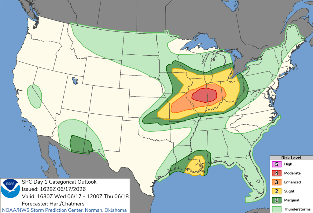
Over the last week, the Midwest has been ravaged by rounds of severe weather, including a rare phenomenon called a derecho and a tornado outbreak. Today, there is a moderate in place over some of the areas already hit and effected by last week’s storms.

In the last week, a Derecho and multiple tornadoes, including two EF-3s, struck portions of Illinois and Indiana. Today, there is a Moderate Risk (level 4/5) of severe weather, in an “all-hazards expected” type of day. Tornado Watches have already been issued, with long track, potentially violent tornadoes possible.

Severe weather strikes the midwest - more expected today

From last week, two of the hardest hit areas were Streator, IL and Koutz, IN. Multiple meteorologists and storm chasers were covering these storms as they moved through the area. Some tornadoes were estimated to be stronger, but simply didn’t do damage to gain a higher rating. This would include Dwight, Washburn, and Ipava, IL.

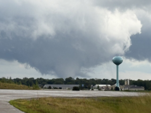
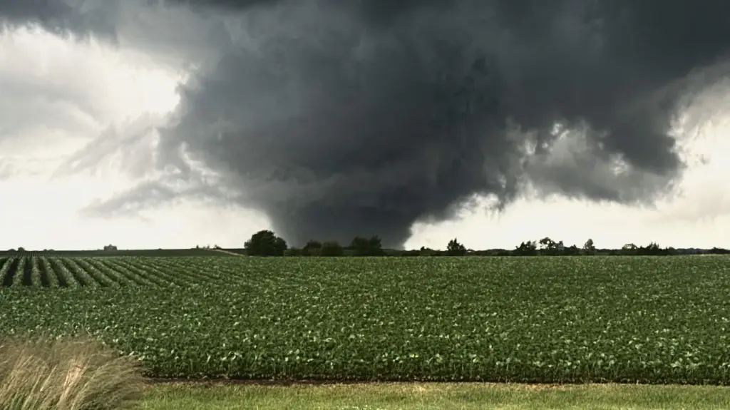
From Left to Right: The Dwight, IL tornado. Credit: Tim Cygnar; The Ipava, IL tornado. Credit: Storm Chaser Jared King. The Washburn, IL tornado. Credit: Meteorologists Brandon Weart and Daniel Wefer.

The Faytuks Weather team will be monitoring and tracking Severe Weather throughout the afternoon, and updating on our X Account as the day progresses.

Weather Update 5.18.26

A potentially extremely dangerous day is possible today throughout portions of the central US. This follows after a damaging tornado occurred yesterday near St Libory Nebraska, where two homes were destroyed.

Today, the Storm Prediction Center (SPC) has issued a Moderate, with EF2-3+ tornadoes likely. Within this moderate risk, they have issued a Particularly Dangerous Situation (PDS) Tornado Watch, in portions of northeast Kansas and southeast Nebraska. Some big cities included in this watch are Salina and Manhattan Kansas. On this watch, there’s an 80% chance of 2 or more tornadoes, and an 80% chance of at least 1 significant tornado (EF2+). Not only are tornadoes a massive concern, there’s also a very good risk for hail exceeding 4+ inches in diameter, around the size of a softball. In the mesoscale discussion posted before the watch was issued, it was stated that “A favorable environment for all severe hazards–including very-large/giant hail and strong to intense tornadoes–will develop through the afternoon.”

Along with the moderate risk, there are also active fires located in southern California, along with an extremely critical fire risk in the Texas and Oklahoma panhandles, portions of far east New Mexico, and far southwestern Kansas. The Sandy Fire, located just south of Simi Valley, California, has burned as of writing, 139 acres. An Evacuation order is in place for Simi Valley zones 32, 33, 34, and 35, all being in the Go phase. Zones Simi Valley 31, Thousand Oaks 06 and 07, are all in the Set phase. Simi Valley is also the location of the Ronald Reagan Presidential Library, which is just outside of zone Simi Valley 31.

The Faytuks Weather team will be monitoring all of these threats throughout the rest of the day and update as needed.


Weather Update 5.16.26

The Day 1 Outlook by the Storm Prediction Center (SPC) for May 16th, 2026.

This weekend is shaping up to be a historical severe and fire weather weekend in the central US. Over the next four days, the Storm Prediction Center has two Critical Fire Risks, and one Extreme Fire Risk, along with three straight Enhanced risks for severe weather, along with a 15% contour for severe weather on Tuesday (Equivalent to a Slight Risk).

Starting with the Fire Weather. Fire Weather is when a combination of dry fuels, low relative humidity, high temperatures, and high winds all mix together to create conditions that are how we get those massive wildfires. The biggest day for the conditions, are on Sunday. This is when that Extreme Fire Risk is in effect for portions of the Oklahoma and Texas panhandles, along with far east New Mexico. Winds are forecasted to be sustained between 25-30 mph (40-48 kph), with a relative humidity forecasted to be between 5-15%. Wildfires have already ravaged parts of the Texas panhandle, including in Randall County, where the Hunggate Fire has already burned for 14,000 acres and as of writing, is only 40% contained. Also as of writing, fires are starting to spark in the Oklahoma panhandle, due to dry thunderstorms. Dry thunderstorms are storms in which thunder and lightning occur, but any rain evaporates before it reaches the ground due to atmospheric conditions.

Moving onto Severe Weather, there are three straight days of enhanced risks (Level 3/5). For today, the risk is centralized over parts of northern Kansas, far northeast Colorado, and southern Nebraska. Today, the biggest concern is for strong winds and large hail, though a strong tornado is also possible. How today plays out, will also have an impact on tomorrow’s potential Tornado Outbreak.

For Tomorrow, there’s an Enhanced risk with a 15# (15% chance of an EF2+ tornado) over the Iowa/South Dakota/Nebraska border. The day is expected to start out with isolated supercells, before forming a line going across the region, bringing strong winds (potentially 75+ mph) and large hail. The general area for those supercells is extremely narrow. The bowing segment is forecasted to be going from northeast Colorado, through central Kansas, and heading northeast through towards Sioux City.

For Monday, for the first time since the introduction of the system earlier this year, a 30## (30 CIG2), indicating that severe weather is extremely likely. This includes the risk of large hail (2+ inches) and strong to intense (EF2-EF3+) tornadoes. While we aren’t entirely sure on how it will play out, mainly due to uncertainty in storm mode (will it be super cellular, or remain linear), it is shaping up to be a historic day.

Tuesday is mostly unknown at this time, due to seeing how the rest of this weekend plays out. At the time of writing, it’s expected to be a mostly damaging wind/hail threat.

The Faytuks Weather Team will be monitoring this weekend, and will be updating both here on the website, and on the twitter.

U.S. Severe Weather Update – April 27th, 2026

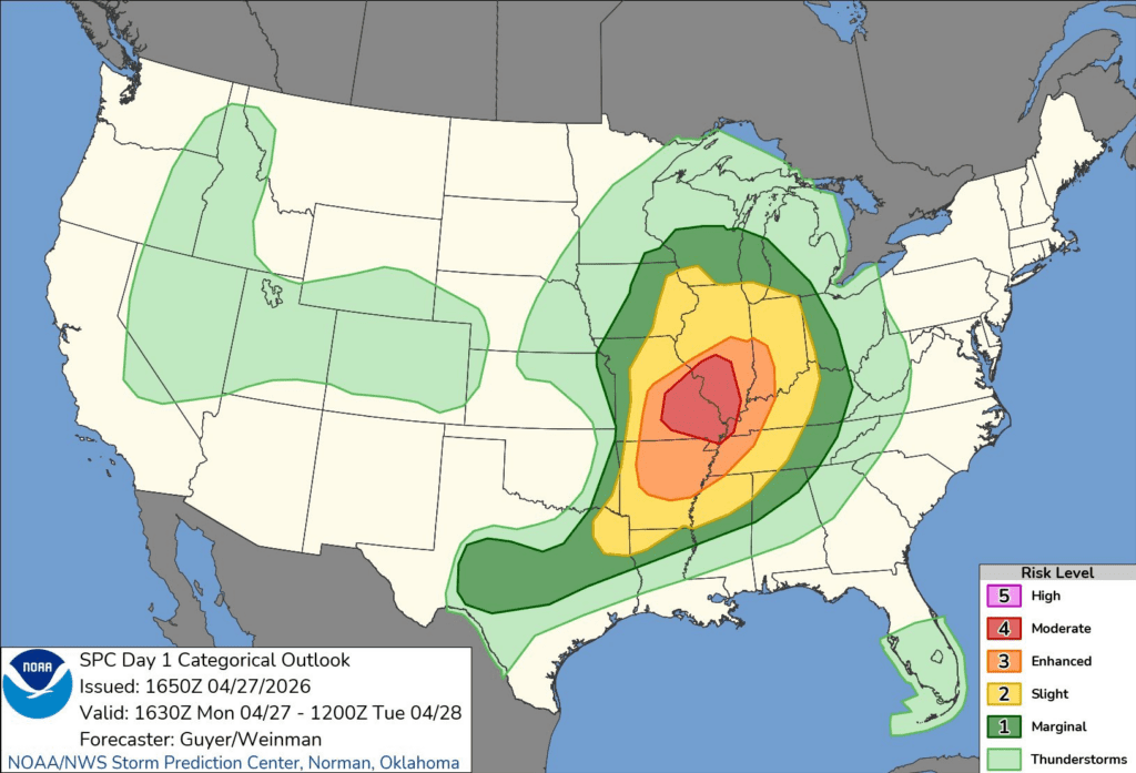
NWS Storm Prediction Center Day 1 Outlook

The Storm Prediction Center has issued a Moderate risk (Level 4/5) today in an all hazards type severe weather day for portions of eastern Missouri and southwest Illinois. Within this risk, there is a 15% CIG (Conditional Intensity Group) 2 for Tornadoes. What this means, is that within a 25 mile radius of hose in that risk, there is a 15% chance of an EF3 tornado, which would indicate winds between 136-165 mph, or 219-265 kph. Tornadoes aren’t the only risk today though, as there is also a 45% wind risk, which would indicate a good chance of severe wind gusts of over 60 mph or 64 kts. Finally, there is also a 30% CIG 1 risk for Hail, which means that there is a 30% chance of hail that is 2+ inches in size, or about the size of a hen egg.

Nws storm prediction center day 1 outlook
Day 1 severe weather outlook. Image: NWS/SPC

The reason why this severe weather set up is so interesting, is that as of writing there is a line of storms going through Central Illinois. What this should do is limit the atmosphere and it’s ability to recover instability to make this outbreak more widespread. Unfortunately, even with that line of storms going through up north, meteorologists are still very confident in the main moderate risk. Overall, it has been shaping up to be a big severe weather impact day.

Due to the severe weather forecasted, over twenty school districts within the St. Louis metro either have closed, or will close early today. If you are placed under a warning today, ensure you are sheltering in a sturdy building, in the lowest interior room with no outside walls. Make sure you are wearing or have closed toe shoes ready, and bring a helmet if you can! If you are caught driving, do not shelter under an overpass. Being under an overpass during any type is dangerous as the overpass almost acts as a tunnel for wind and rain.

The Faytuks Weather team will be monitoring this event throughout the day, and posting updates to the twitter as we can.

LIVESuper Typhoon Sinlaku to make Landfall in Northern Marina Islands

Super Typhoon Sinlaku as it nears Guam and the Northern Mariana Islands

Guam and the Northern Mariana islands are hunkering down late today in preparation for the direct hit of Sinlaku, one of the strongest Super Typhoons to hit the Northern Mariana Islands in history. The territory is currently in a Condition of Readiness 1 (COR 1), the all clear level would be a Condition of Readiness 4. The Super Typhoon has sustained winds of 165 mph, which would be equivalent to a Category 4 Hurricane on the Saffir-Simpson Scale. Leading up to the storm, as of 8:53 am ChST (22:53 UTC) 851 people were in emergency shelters across the island of Guam, in multiple different schools. This is only 32% of the official capacity of said shelters.

The Guam Power Authority (GPA) as of 10:35 ChST (0035 UTC) was aware of multiple outages within the territory, with only about 50% of power flowing to distribution feeders. Outages can be reported to the GPA 24 hour dispatch line, or at the GPA’s Facebook Page. The Guam Waterworks Authority (GWA) reported that 4 wells are offline due to power fluctuations, causing little to no water pressure within parts of a few of the largest villages, Dededo and Barrigada. The GPA has generators that are able to be provided to the GWA. As of writing, all sewer pump stations and wastewater treatment plants were all online. According to the Guam Memorial Hospital Authority (GMHA) all essential hospital services are able to continue, including operations and inpatient care. Community Health Centers are accepting patients for any care that may be needed throughout the duration of the storm.

The following areas in Guam as of 8 AM ChST were reported to be without water:
Dededo, Ironwood
Piga Subdivision
Nevermind Road, Ysengsong
Sanches-Setbaru Street, Leyand Barrigada.

In the Northern Mariana Islands, Saipan, Tinian, and Rota are under Typhoon Condition I, which means that Damaging Winds of 74 MPH or more are expected within the next 12 hours. Pagan, Almagan, and Agrihan are also under Typhoon Condition I, which means that damaging winds of 39 mph or more are expected within 12 hours, with the onset of Typhoon Force Winds of 74 mph or more forecast through Wednesday. A Shelter in Place order is in effect, with multiple shelters open within Saipan, Tinian, and Rota. Once Typhoon Condition I was declared, all Commonwealth Healthcare Corporation (CHCC) outpatient clinics and Health Centers were closed. All Emergency Rooms will remain open. All beaches within the commonwealth are closed until further notice. All schools were closed Monday until further notice. Northern Marianas College and the Northern Marianas Technical Institute closed aswell on Monday, until an “All Clear” is given. As of 8 am ChST, a shelter-in-place was issued for the Commonwealth until further notice.

A High Wind Warning was issued by NWS Guam until 6:15 pm ChST Tuesday for Saipan and Tinian for Typhoon force winds of up to 155 mph possible, with winds of at least 115 mph expected. As of 3:30 PM ChST, at Saipan airport reported winds of 104 mph, withs gusts of 161 mph.

Faytuks Network will be updating this page as the day goes on with updates of impacts to the area.